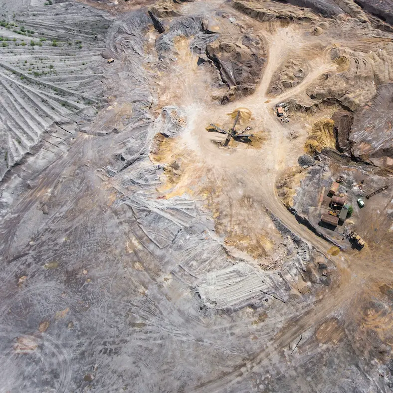
The Mount Nansen mine Yukon produced 41,500 ounces of gold and 234,200 ounces of silver between 1968 and 1999. It also left behind 540,000 tonnes of tailings, 800,000 tonnes of potentially acid-generating waste rock, and a contamination legacy that will cost Canadian taxpayers tens of millions of dollars to address — a clean-up that is not expected to be complete until the early 2030s.
The site is not an outlier. It is one of eight abandoned mine sites in the Yukon and Northwest Territories managed under Canada's Northern Abandoned Mine Reclamation Program, backed by $6.9 billion of federal funding committed through to 2035. Across northern Canada, the pattern repeats: a company extracts mineral value, operations become uneconomic, the site is abandoned, and the environmental liability passes to government, to taxpayers, and to the Indigenous communities on whose traditional territory the damage occurred.
Mount Nansen is worth examining in detail — not to relitigate decisions made decades ago, but because the ground conditions that created the contamination problem were knowable before mining began. The geology, the hydrology, the acid-generating potential of the waste rock, the sensitivity of the receiving environment — these were not surprises that emerged only after operations ceased. They were characteristics of the site that thorough early-stage ground screening would have documented.
This article is a factual account of the Mount Nansen mine site: its history, its geology, its contamination legacy, and what it illustrates about the value of early-stage site assessment in mining exploration.
Mount Nansen mine is located approximately 60 kilometres west of Carmacks in the central Yukon, Canada, within the traditional territory of the Little Salmon/Carmacks First Nation — known in Northern Tutchone as Enozhí Ddhäw. The site sits along Pony, Back and Dome Creeks, which flow into Victoria Creek and the Nisling River.
Geology of the Mount Nansen Mine Site
Mount Nansen itself is a deeply eroded Mid-Cretaceous stratovolcano located in the Dawson Range of the central Yukon, rising to 1,827 metres above sea level. The volcanic complex consists of rhyolite, dacite and andesite flows, breccias and tuff — all formed during a period of subduction under North America approximately 100 million years ago.
This volcanic geology is significant for mining because volcanic arcs and their associated hydrothermal systems are classically associated with epithermal gold and silver mineralisation — the type of deposit exploited at Mount Nansen. The same geological processes that concentrate precious metals also commonly produce sulphide minerals in the surrounding rock and waste material. When sulphide-bearing waste rock is exposed to air and water through mining operations — in open pits, in tailings storage facilities, in waste rock dumps — it can oxidise and generate sulphuric acid. This acid then dissolves heavy metals from the surrounding rock, producing contaminated leachate that migrates into groundwater and surface water.
This process — acid rock drainage — is one of the most significant and persistent environmental challenges in hard rock mining worldwide. At Mount Nansen, the Canadian federal government's own documentation identifies potentially acid-generating waste rock and potentially acid-generating tailings as the primary environmental concerns on site, alongside soils with elevated concentrations of metals and impacted tailings water.
The geology of the site did not make acid rock drainage inevitable. But it made it a foreseeable risk — one that thorough geological characterisation before and during mining operations should have identified and planned for.
History of Mining at Mount Nansen Yukon
Mineral exploration at Mount Nansen began in the 1940s. Active mining occurred across three distinct periods:
The Scale of the Mount Nansen Mine Environmental Legacy
The contamination concerns documented at Mount Nansen include soils with elevated concentrations of heavy metals, acid-generating tailings leaching into receiving waterways, and impacted tailings water that required an emergency water treatment intervention in 2024. The Little Salmon/Carmacks First Nation — whose citizens have used the area for traditional activities, subsistence hunting and gathering since time immemorial — has consistently raised concerns that contamination in and around the site has been increasing more than two decades after the mine was declared abandoned, and that water treatment at the site has been addressing only a fraction of the contaminants of concern.
The environmental and human cost of this situation is significant and ongoing. The financial cost to Canadian taxpayers is part of a $6.9 billion federal remediation programme covering eight northern abandoned mine sites, of which Mount Nansen is one of the smaller projects.
What Mount Nansen Reveals About Ground Screening in Yukon Mining Exploration
It would be historically inaccurate to suggest that the problems at Mount Nansen resulted simply from a failure to do preliminary ground screening. Mining practices, regulatory frameworks and environmental standards have changed substantially since the 1940s, 1960s and 1990s. What was permitted, what was required, and what was understood about acid rock drainage and tailings management has evolved considerably.
What the site does illustrate clearly is the relationship between geological characteristics, ground conditions and long-term environmental liability — and why understanding those characteristics thoroughly at the earliest possible stage of exploration is fundamental to responsible site assessment.
The geology signalled the risk
Volcanic arc geology with associated epithermal mineralisation and sulphide-bearing country rock is a known acid rock drainage risk environment. The rhyolite, dacite and andesite flows, breccias and tuff that characterise Mount Nansen's volcanic complex are not geologically neutral materials in an open-pit mining context. A thorough early-stage geological assessment of a site with this profile would flag acid-generating potential as a primary geohazard requiring specific consideration in mine design, tailings management and site closure planning.
The hydrology amplified the consequences
The site sits along Pony, Back and Dome Creeks, which flow into Victoria Creek and the Nisling River — a watercourse system that the Little Salmon/Carmacks First Nation has depended on for traditional activities and subsistence for generations. Contamination introduced into this drainage system does not stay on site. The hydrological connectivity between the tailings storage facility, the receiving creeks and the broader watershed is exactly the kind of environmental sensitivity that early-stage hydrogeological assessment is designed to identify.
The permafrost context mattered
Central Yukon contains areas of discontinuous permafrost. Permafrost conditions affect tailings behaviour, seepage patterns, drainage system design and the long-term stability of engineered structures including tailings dams. In permafrost-affected terrain, the design of tailings storage facilities requires specific geotechnical consideration that goes beyond what is required in temperate environments. The 2024 emergency at the Mount Nansen tailings storage facility — where the Yukon Water Board determined that untreated water posed an immediate environmental risk — illustrates how tailings management in northern environments requires sustained geotechnical attention across the full life of the site.
The Remediation Plan and What Comes Next for Mount Nansen
The preferred remediation option agreed by the governments of Canada, Yukon and Little Salmon/Carmacks First Nation in 2012 involves:
- Backfilling the Brown-McDade open pit with tailings and contaminated material from across the site
- Installing an engineered cover over the pit
- Removing the tailings dam
- Restoring the Dome Creek valley
- Demolishing the mill and remaining surface infrastructure — completed in 2025
The formal project proposal is expected to be submitted to the Yukon Environmental and Socio-economic Assessment Board in 2025, with the assessment and permitting phase expected to conclude around 2029. Active remediation would then take approximately three years. Long-term environmental monitoring will follow.
The Little Salmon/Carmacks First Nation has raised consistent concerns throughout this process about the adequacy of the cleanup, the treatment of only a fraction of the contaminants of concern, and the pace of progress. Chief Russell Blackjack of the First Nation has stated publicly that the community wants the site cleaned properly, including the tailings pond, because the legacy contamination will affect the land for generations. These concerns remain unresolved as of the date of this article.
The Mount Nansen mine remediation is an active and contested process. The Little Salmon/Carmacks First Nation has formally disputed the adequacy of remediation work and raised concerns about treaty obligations. Readers seeking current information on the status of the site and the First Nation's position should consult the Mount Nansen Remediation Limited Partnership website and Crown-Indigenous Relations and Northern Affairs Canada directly.
Early-Stage Ground Screening in Yukon Mining Exploration Today
Modern mineral exploration in the Yukon operates under significantly more robust regulatory requirements than those that governed mining at Mount Nansen in the 1960s and 1990s. The Yukon Environmental and Socio-economic Assessment Act, the Yukon Waters Act, and the requirements of the Yukon Environmental and Socio-economic Assessment Board all require meaningful environmental assessment before significant exploration or development activities proceed.
But regulatory compliance and thorough early-stage ground screening are not the same thing. Regulatory requirements establish a minimum standard. Thorough ground screening at the earliest possible stage of exploration — before capital is committed, before infrastructure is positioned, before the scope of potential environmental liability becomes clear — serves a different purpose. It gives exploration teams, investors and regulatory bodies a clearer picture of what a site involves before the decisions that are most expensive to reverse have been made.
The specific ground condition factors that a preliminary site context assessment for a Yukon exploration site should address include:
- Geological characterisation — rock types, mineralisation style, sulphide content and acid-generating potential
- Permafrost and frost hazard assessment — extent and character of permafrost, implications for site infrastructure and tailings management
- Hydrogeological context — surface drainage, groundwater connectivity, receiving water sensitivity
- Geohazards — slope stability, seismic risk, flood risk in the context of northern hydrology
- Environmental sensitivity — proximity to watercourses, fish habitat, traditional land use areas
- Historical land use — prior exploration or mining activity and any associated legacy contamination
None of these factors require fieldwork to assess at a preliminary level. Publicly available geological mapping, hydrogeological data, environmental databases and historical records provide a substantial evidence base for early-stage site context assessment before any physical investigation is commissioned.
A preliminary desktop site context report — covering geology, permafrost risk, hydrogeology, geohazards and environmental sensitivity — is the appropriate first step before committing exploration budget to a Yukon or northern Canadian site. It does not replace the detailed environmental and geotechnical investigations that will be required before development proceeds. What it does is establish the ground condition context that informs whether a site is worth pursuing further, and what the key risk factors are likely to be.
Is this site worth committing exploration budget to?
Generate a preliminary geological, geotechnical and environmental site context report for any exploration target in Canada, Australia, Africa and beyond. Understand the ground context before fieldwork begins. From $19.
Generate an Exploration Screening Report →- Crown-Indigenous Relations and Northern Affairs Canada — Mount Nansen Mine Remediation Project (March 2026)
- Mount Nansen Remediation Limited Partnership official website
- Government of Canada — Mill Demolition Marks Progress Toward Mount Nansen Site Clean-Up (October 2025)
- CBC News — Board approves emergency plan to prevent tailings spill at Yukon's Mount Nansen mine site (April 2024)
- CBC News — Ottawa dismisses Yukon First Nation's concerns regarding Mount Nansen mine clean up (February 2024)
- Wikipedia — Mount Nansen (Yukon)
- Northern Abandoned Mine Reclamation Program — Crown-Indigenous Relations and Northern Affairs Canada